
|
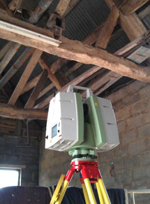
Grantham Coates Surveys staff have been laser scanning using the latest state of the art Leica Laser Scanners for over 8 years. We have gained experience and the confidence to tackle almost any laser scanning task, be it a simple building scan for 2D elevations, large scale plant environment for 3D model creation or extensive heritage surveys requiring highly detailed record drawings to be produced.
Examples of projects where 3D Laser Scanning can be applied include the following:
Laser scanning provides a fuller and more detailed survey than traditional surveying can ever come close to. The benefits include:
|
|
Examples

|

|
|
Laser scan of Buttercross
|
Data "point cloud" produced by a laser scanner
(from different viewpoint) |
|
Images and scan point clouds from laser scan projects:
|
View our "fly through" example point cloud:
For further information regarding projects that we carry out, please visit our Social Media platforms!
|
For a further insight into the type of work we cover please visit our Social Media platforms.
Sample drawings are available upon request - please Contact Us for further details.
Sample drawings are available upon request - please Contact Us for further details.
Wherever spatial information is required we shall be pleased to discuss your requirements with you.
Please call us on 01789 764420 or email us at [email protected]
Please call us on 01789 764420 or email us at [email protected]
"Thanks for your top quality service this year, your professionalism and quality deliverables make my job a lot easier"
|
|
|
|
